
Lost Massachusetts
By Garth Bruen

Lost MassachusettsOct 30, 2021

Spa E49

Comments and Notes E48
In this episode we respond to listener postcards, letters, emails and Internet comments. The comments cover recent episodes including MVM E46, Myrtle Village E45, Workmans Circle Camp E44, Southerton, Mass: Velvet Mill E43, Vos Haven E42, Mechanic Street E41 and The Arsenal E40. Listeners provide additional personal context for these stories and tell us which topics were their favorites. More information at LostMassachusetts.com

Out There E47
In Out There Episode 47 we discuss some of the odd history and findings out in Boston Harbor, particularly the Bug Light. We also demonstrate how to dial into various navigational devices and collect data from them... Sources, credits, photos, links and more information at LostMassachusetts.com

MVM E46
Did you grow up near or have you ever seen mysterious castle buildings with the enigmatic "MVM" carved over the door? In this episode of Lost Massachusetts we will explain the meaning behind MVM and the history of the castle buildings... Sources, credits, photos, links and more information at LostMassachusetts.com

Myrtle Village E45
Major highway projects can bring prosperity, ease of travel but can also cut through the soul of a community and make it vanish. In this episode we learn about how the Turnpike Authority cleared out swaths of homes in West Newton and Auburndale Mass. Myrtle Village formed around the Myrtle Baptist Church, which still stands today as a testament to the perseverance and faith of a community. However the construction of the Pike left visible scars on the neighborhood which can still be seen with a careful eye. A jumble confusing traffic patterns, dead ends and oddly configured streets make it obvious that the area used to look completely different.
We also discuss what a "Turnpike" is anyway and how the famous Star Market ended up straddling the highway.
By the late 1940’s routes 9, 20 and 30 were already completely congested with traffic. In an attempt to address the growing need for roads, one of the greatest monsters in Massachusetts history was created. Like most monsters this was a hybrid of two things. The key power of this monster is Eminent domain which gives the government the authority to seize private property in the public interest if they compensate the owner.
Sources, credits, photos, links and more information at LostMassachusetts.com

Workmans Circle Camp, MASS. E44
If you are driving through Ashland Mass you might notice something odd pop up on your GPS: a designation called “Workman’s Circle Camp” and if you zoom in you will see streets arranged in a semi-circle. If this made you really curious and you turn off the main road to drive through you won’t find anything that looks remotely like a camp of any kind.
This is a ghost on the map and its real name is a further ghost. In Yiddish it would have been called Der Arbiter Ring.
The 19th century saw a flood of European immigrants the east coast of the united states. Like many of these immigrant groups Jews from central Europe found themselves in the middle of what were at the time, the most crowded cities on the planet. These were cramped places full of tenements, sweatshops, poverty, oppression, crime and unfamiliar faces speaking dozens of different languages or dialects.
Out of this chaos emerged a movement to not only escape the city but to preserve culture. In 1927 the site of an old mill in Ashland was purchased by the Jewish Workmans Circle and became the site of a kind of tent city called the Golden Ring Camp.
Listen to the episode to find out the full story and get all the information at Lostmassachusetts.com

Southerton, Mass: Velvet Mill E43
Join Lost Massachusetts on this mystery road trip and what we found at the end of it...We take an unexpected tour of a liminal space inside the lost town of Southerton Mass. Never heard of Southerton? It was and still is there. You can see it too.
Show notes, sources and more information at LostMassachusetts.com

Vos Haven E42
We continue our investigations into Lost Dutch Mass (See Episode 25 Niew Nederlandt). On most early maps the area of current Boston Harbor is recorded as “Vos Haven”. Vos Haven is Dutch for Fox Harbor. This was no doubt named because of the abundance of foxes which are still prevalent in Massachusetts today. As the English gradually became dominant in the region and took more territory through a series of global and local conflict they replaced Dutch names with English ones. However, the English still had a problem with names that many people were already familiar with. The Puritans may have come up with a clever solution to make a particular place “english” while preserving the moniker travelers were used to.
In order to understand this we have to plunge into the history of how Massachusetts capital got its name which on inspection starts to fall apart. The Puritan Colony capital went through a few iterations before a name was selected but it seems to have been pulled out of thin air. Stories and explanations may have been backfilled later. Listen to the episode to learn more.
Also explained in detail is exactly how the Dutch lost their massive global empire. We reference Lotharingia by Simon Winder which covers the lost European country of Lotharingia. Not only is this a good reference for our topic it also illustrates how such large territories can be erased from maps and forgotten.
Show notes, sources and more information at LostMassachusetts.com

Mechanic Street E41
About the time of Paul Revere’s death in 1818 the street name Mechanic Street begins to appear on maps in Boston's North End. This narrow street, connecting what was then Middle Street and Fish Street, was also connected to Board Alley in the center, forming a ladder on some maps or an arch on others. Mechanic Street in Boston is barely a street anymore. One end was cut off when the Sumner Tunnel was constructed and the other is now outdoor seating for a restaurant. This location is on the Freedom Trail but it is not part of a tour, there is no historical marker. This is a block away from Revere’s house but any connection to him is not drawn even though it easily could be.
Mechanic in this context is unrelated to automobiles or garages. This is an archaic, old-world definition of Mechanic that refers to people who work with their hands in a number of skilled crafts. One might guess the name of this street is intended to reflect Boston’s rising class of citizen artisans, but could it mean something much more in addition to that?
Throughout the nineteenth century Mechanic Streets begin appearing in towns across Massachusetts, over 70 in fact, many with a very specific configuration. Is there a lost meaning in the street layout itself? In this episode of Lost Massachusetts we begin looking at the lost history of Mechanic street to see where it takes us.

The Arsenal E40
The Watertown Arsenal is a property that has had many lives. It is mostly known today as a shopping center but for 175 years it was a U.S. Army research facility responsible for some of the most critical innovations in military technology, many of which ended up in civilian use later. It started as an Army base for storing munitions after the War of 1812 but was used to make new kinds of artillery in the Civil War. The focus on artillery continued in the 20th century turning the base into a sprawling factory, making essential contributions to the war efforts throughout the decades. In its Cold War phase the research became focused on creating new materials. The site was host to a one-of-a-kind nuclear reactor in the 1960's. Its operations gradually wore down and the property has been sold off in pieces, most famously becoming a premier shopping mall in the 1980's. For a time this was a dead mall but has been reimagined as Arsenal Yards. The vast property is a patchwork of public parks, businesses, crumbling factory buildings, gardens, classic architecture and mysterious underground tunnels. Some of the land has been contaminated at various times by the research conducted at the Arsenal, some of which is still classified. Most of the Arsenal is open for exploration.

Listener Comments E39
In this episode we play a clip from our interview with Noah Hatton on WPKZ Fitchburg and respond to listener comments. We also puzzle over other things that come up in searches for Lost Massachusetts. Locations of possible future episodes are revealed as well.
The K-Zone WPKZ 105.3FM/AM1280 01 - 20 - 23 PODCAST REPORT
Lost or stolen Mass Driver's License
Reinstate your driver's license
Get at Lost Massachusetts Postcard from a Lost Place
Photos at: instagram.com/lostmassachusetts
Sound Effects From Zapsplat (zapsplat.com)
Music Courtesy of Free Music Archive (freemusicarchive.org)

Borderland E38
In this Lost Massachusetts Episode we take a zig-zag drive through the Mass/Conn border examining the odd crossings between Southwick, Mass & Granby, Conn; Longmeadow, Mass & Enfield, Conn; and a 12-second crossing in the Douglas State Forest. There are also waterfront properties where the house is in one state but the beach is in another.
Take a good look at the Mass/Connecticut border, it's not a straight line, not even close. From New York the mass border slopes north, then south, then drops into Connecticut for miles in places, slopes north again, then south again and then finally straight down where it meets the Rhode Island border.
A bad survey line established in 1642 marked a disputed state line that placed a dozen or more Connecticut towns within Massachusetts. It would take almost two hundred years to settle this dispute. Why was the line so inaccurate? Because the people who did it conducted their measurements from a ship instead of on the land. They took measurements from the ocean and the Connecticut River which were not much better than guesses.
Connecticut did not even have its own royal charter 1662, it was a mishmash of adjacent colonies centered around New Haven and Saybrook that did not combine until later. This was the period of history where the Netherlands was loosing control to England, including the Dutch possessions in New England.
When they received their charter, Connecticut put its version of the state line well above the 1642 line, but this remained an issue of dispute and confusion between the two states. More settlers moved into the towns not always clear on where they lived.
Connecticut conducted a new line survey in 1695 which massachusetts ignored.
Mass did not like the results from another survey conducted in 1702 either. in 1713 the two colonies simply agreed to divide up the towns in the disputed area, but the towns impacted by the change did not like being tossed around so another survey was chartered. Strangely, the new border agreed to by massachusetts put several towns that were clearly settled by massachusetts in Connecticut. These towns were shifted back to massachusetts which made the various jogs we see on the map. If you think this ended the issue it did not since some settlers in massachusetts wanted to be part of connecticut because the taxes were lower. Imagine that. So the border shifted again for some people. In 1797 part of the border was adjusted because a river used as a marker had...moved. After the revolution the issue was revisited in 1801 but was not redrawn until 1826 and agreed on until 1840. All of this confusion was compounded by the fact that many stone markers, while intended to show the actuate borders were in the wrong place. It was also found that some settlers have moved marker stones to expand their own farms. These discrepancies were not fixed until 1941. The issues did not end there as new technology in the early 2000s made more accurate measurements and these results showed many border lines to be invalid. Believe it or not, Connecticut's eastern border with Rhode Island is still in dispute.
These are the towns above the 1642 survey line: Thompson, Woodstock, Union, Stafford, Somers, Enfield, Suffield, Granby, Windsor Locks, Hartland, Barkhamsted, Winchester, Colebrook, Norfolk, Canaan, Salsbury, Millerton NY.
The towns specifically settled and claimed by Massachusetts: Woodstock, Somers, Enfield, Suffield.
Sources, photos and more information at lostmassachusetts.com

Massachusett E37
What exactly is "Massachusetts" anyway? Where is the real, original Massachusetts? In this episode we explore the name and initial location it refers to. This is a good starting point for exploring the deep history of Lost Massachusetts.
The word Massachusett (sometimes Massachuset - with one T) loosely translates as: "at the range of hills" in the Algonquin dialect spoken by the native people of Massachusetts. The hills referenced in the term are the Blue Hills and in particular the Great Blue Hill in Milton.
The people referred to as Massachusett ("Massachuseuk") controlled an area much smaller than the current size of the state. Its frontier was roughly from Cape Ann in the North, Natick in the West and Weymouth in the South.
What became the colonist state of the Massachusetts Bay Colony also did not include Plymouth plantation, the Cape and Islands (The "Old Colony") or generally lands further to the West or North until later.
The Blue Hills Reservation is in Milton, Randolph, Quincy, Canton and Dedham. This is four-season recreational area with hiking, skiing, swimming, mountain biking. There are bathrooms, picnic areas, boat launches, a nature center and museum run by Mass Audubon.
The relationship between this location and the name of our state is not made plain or explained clearly. This was also likely the location of an important native settlement and possibly a place of religious significance - subjects that need to be explored in more depth.
Sources, Links, Photographs and more at LostMassachusetts.com

Show Notes Show E36
We briefly discuss pending changes to the show format, making shorter, more targeted episodes that will hopefully enable quicker releases and more overall coverage of fascinating lost places and the stories behind them.
Archaic word of the Episode: Calash.
Also, check our our new Lost Cabin artwork. Cool, huh? It's by local artist Ellie Jones. Go to lostmassachusetts.com or lostmassachusetts at Instagram for more information about Ellie Jones artwork and the show.

The Fo'Castle E35
Outermost house of Henry Beston. Come with us over the sand dune cliff to search for Henry Beston's lost Outermost House in the most recent episode: The Fo'Castle E35.
"Sleep gone and past recapture, I drew on my clothes and went to the beach. In the luminous east, two great stars aslant were rising clear of the exhalations of darkness gathered at the rim of night and ocean-Betelgeuse and Bellatrix, the shoulders of Orion. Autumn had come, and the Giant stood again at the horizon of day and the ebbing year, his belt still hidden in the bank of cloud, his feet in the deeps of space and the far surges of the sea." From The Outermost House.
Quincy native Henry Beston joined the French Amy in 1915 and served as an ambulance driver. Like Ernest Hemingway, he wrote about his experience, also like Hemingway he became a journalist for a time, covering the war. He knew cape cod from studying coast guard stations along the cape for a magazine. The recently formed Coast Guard provided, and still provides, a critical service in the area. The ocean around Cape Cod is one of the most dangerous places in the world to sail.
Looking for solace, Beston we went to the beaches of Estham, the furthest point out, as far as he could be from the world, as close to the sea as he could be. He spent a year looking for what he called the Devine Mystery of Nature where a man could cease being a man and become part of something else. He would study and record the sights and sounds of nature. The book he created is cited as the impetus for the preservation of Cape Cod’s natural resources. Beston’s book changed the way people thought about nature, not just something to be feared but also something to be respected and managed.
About ten years after the house was built a storm nearly destroyed it, so it was moved back. 10 years after that, the dune it sat on started to collapse so they moved it again, this time behind the dune. But the sea takes what it wants to. In February of 1978 the Fo’castle was pulled into the ocean by one of the most powerful and destructive storms in the history of Massachusetts, our famous blizzard, a single storm that left 27 inches of snow, shut down the state for a week and killed over 100 people. Not only was the house lost, but the very ground it stood on is now under water.
Sources, Links, Photographs and more at LostMassachusetts.com

Dogtown, Mass. P3: Redemption E28
Once a place of despair, mischief and mystery, Dogtown is now place for inspirational hikes. This is a follow up to Episode 2: Ghost Towns and Phantom Roads and Episode 6: The Accursed Land. In this episode we focus in the physical transformation of Dogtown by Roger Babson and the historical preservation of the cellar hole sites. Visit the episode blog for photographs and details. You will need three maps: 1. Dogtown Cellar Hole Map, 2. Babson Boulder Map 3. Dogtown Trail Map (shout out to Cape Cod author Eric Bickernicks for collecting all of this information).
Sources, Links, Photographs and more at LostMassachusetts.com

Boston's Dying Gaslight E34

Viking MASS E33
Viking MASS part one...It is claimed by many people that there was viking exploration and even settlement of Massachusetts seven or eight hundred years ago, long before any other European’s arrived. Did this happen? How valid are the claims? Is it possible? Where is the evidence?
First Who were the vikings? These are various medieval people originating out of Sweden, Norway and Denmark who became notable for raiding coastal settlements in Europe in the ninth century from Russia to the British Isles. They often raided monasteries that were undefended for the gold. The image conjured in many people’s minds of vikings is the raiding and piracy, but what is more interesting for this discussion are the expansions, settlements and take over of various European territories by vikings. It surprises people to find out that Dublin Ireland was a viking settlement, and that parts of England and France were viking-sized. This helps answer the question as to why Vikings might have pushed deep into north america. This story is not about raiders and pirates, it’s about the need for new territories to move people into. Some of the motivation was about inheritance or rivalries between siblings that led them to want to find unexplored territories, especially places where they wouldn’t have invade with an army.
We begin our story by visiting the statue of Leif Erikson on Commonwealth Avenue in Boston near Kenmore Square. This is one of many monuments in the area dedicated to Viking exploration. Some are at locations claimed to be actual landing sites or possible settlements. We will attempt to visit and evaluate many of these in parts 2 and 3.
Sources, Links, Photographs and more at LostMassachusetts.com

Chestnut Hill Does Not Exist E32
Chestnut Hill Does Not Exist...or does it???
Full Blog at lostmassachusetts.com
We cover the lost history of a town that was never a town but was planned to be. It's not a ghost town, you can still go there: Chestnut Hill. People may imagine it is a distinct town but it is made of pieces of several other cities. How? Listen to the podcast. The Lee family acquired over 160 acres of what many people considered to be remote, rural, dusty, swampy land on the Newton-Brookline border. Part of that land would be transferred to Roxbury. The Lee's would develop the land, bringing families in, clearing it, building roads and houses and then renaming the area "Chestnut Hill". Their goal was to create a new community but Boston's ambitions made that just a dream as the suburbs tightened their borders in response.
"Named by Francis Lee, who built the first country house in the area in the 1850's, Chestnut Hill is in three different towns"(brooklinehistoricalsociety.org)
"That still doesn’t explain the Brookline-shaped gap in Boston’s present-day silhouette, though. Between 1868 and 1870, Boston tripled its size by annexing first Roxbury and then Dorchester, promising new infrastructure and development. In 1873, it grew larger still, absorbing Brighton, Charlestown, and West Roxbury. Brookline, however, would later vote against joining Boston, putting a stop to the city’s inland expansion until it annexed Hyde Park in 1912." (realestate.boston.com)
"The western part of the City of Roxbury split off to form the Town of West Roxbury in 1851. It survived on its own until 1874, when it was annexed to Boston along with Brighton and Charlestown." (guides.bpl.org)
Sources, Links, Photographs and more at LostMassachusetts.com

The Oblong E31
The Oblong - A mysterious phantom territory between Massachusetts, Connecticut and New York.
One might think it is easy to draw three straight lines to a point and say: This is Massachusetts, this is Connecticut and this is New York, but apparently that is actually very difficult and literally took centuries to sort out.
Take a long strange drive with us to the Oblong in our most recent episode.
We also respond to various listener emails and comments.
"she refused to repent, she was led to the gallows once more on June 1, 1660" (webpages.uidaho.edu)
"Connecticut exchanged for the areas of Stamford and Greenwich (which intruded beyond the twenty-mile line) an equivalent amount of land all along the boundary northward to Massachusetts. These ‘Equivalent Lands’ were in a long, narrow ‘Oblong,’ approximately 1 3/4 miles wide." (pattersonhistoricalsociety.org)
"Birdsall sent word to Quaker communities in Long Island, Rhode Island, and Massachusetts, and a few hardy souls bought 500-acre plots around what they quickly christened Quaker Hill." (hvmag.com)
Sources, Links, Photographs and more at LostMassachusetts.com

The World Before - Cornhill E29
Lost Massachusetts Returns...to Cornhill in Truro on Cape Cod. This place represents a pivotal moment in the history of Massachusetts, the site of a lost village now surrounded by summer homes.
There had been encounters between natives of Massachusetts and Europeans for possibly hundreds of years. This was possibly the first time Europeans set foot in a Native American village. It is remembered as the moment Mayflower Pilgrims saved themselves from starvation by taking stored food from what is now known as Cornhill, what was a village of the Pamet people. The Pamet had relocated to their winter homes and were not there when the Pilgrims entered the village. Cornhill gets great ocean breezes in the summer but can be brutal at the time the Pilgrims arrived in November. The Nauset had good reason to be suspicious of the English but eventually became allies after the Pilgrims paid them for the stollen corn later. Find out more details in the second episode from season 2, including some possible information about the Nauset dogs.
"...and also found a place where a house had lately been, with some planks, and a great kettle and heaps of sand newly banked, under which they found several large baskets filled with corn, some in the ear of various colors..." -Bradford's History of Plymouth
The Buried Corn of the Nausets (fourstringfarm.com)
The Creation of the American Dog (archive.nytimes.com)
PRECONTACT (AMERICAN DOGS (in.gov)
Ancient Dogs of the Americas Were Wiped Out by European Colonization (livescience.com)
Nauset Indians (eastham-ma.gov)
A Brief and Ever Growing History of the Town of Truro Massachusetts (truro-ma.gov)
Corn Hill Beach (truro-ma.gov)
Get at Lost Massachusetts Postcard from a Lost Place
LostMass Podcast Reviews at Apple (podcasts.apple.com)
Photos at: instagram.com/lostmassachusetts
Sound Effects From Zapsplat (zapsplat.com)
Music Courtesy of Free Music Archive (freemusicarchive.org)
Lost Haunted Houses: The Bird Lady E30
Lost Haunted Houses: The Bird Lady
In this episode of Lost Massachusetts we read some listener experiences with haunted places and go into detail about the house of the Bird Lady. Listen if you dare...
Get at Lost Massachusetts Postcard from a Lost Place
LostMass Podcast Reviews at Apple (podcasts.apple.com)
Photos at: instagram.com/lostmassachusetts
Sound Effects From Zapsplat (zapsplat.com)
Music Courtesy of Free Music Archive (freemusicarchive.org)

Preview of Season Two E27
Preview of Season Two
First in this episode we thank our listeners for their comments and to pushing us over five thousand listens. We discuss our two most downloaded episodes of Season One: Episode 3 Small Pox Burial Ground and Episode 14 The Lost Corner.
What Episodes and Mysteries to unravel in season two? These are mostly just clues, I’m not giving away the stories and locations all at once, but many of you will probably know exactly what I’m talking about. One of the things I’m finding is that many lost mass listeners really know their local history and when they share their knowledge it makes the show even more interesting.
In the first episode of Season 2 we are going to hone in on a Massachusetts origin story if you would, a crucial moment for two peoples that meant survival for one and decimation for the other. A point of no return in history that is itself a vanished and lost place, even the marker for this most pivotal moment is swept over and hidden. You’ll have to listen to first episode to find out what I mean. But this is something that helps us look both forward and backward in time.
We’ll visit what is left of a community that was blown up and severed by one of massachusetts most iconic roads.
We will try and visit the desolate place one man spent a year expelling himself in from the rest of society.
There will be an episode focusing a secret that is still running under the streets of Boston that you can still see for the moment if you know where to look, but it is vanishing slowly with each passing year so hurry up and go look at it while it’s there.
An unexpectedly extreme but breathtakingly beautiful place that could be dangerous to the causal visitor depending on the circumstances but it is also a place that has a rich bizarre history and still serves as an inspiration to many.
And much much more...
Munich Haus in Chicopee MASS (munichhaus.com)
Get at Lost Massachusetts Postcard from a Lost Place
LostMass Podcast Reviews at Apple (podcasts.apple.com)
Photos at: instagram.com/lostmassachusetts
Sound Effects From Zapsplat (zapsplat.com)
Music Courtesy of Free Music Archive (freemusicarchive.org)

The Postcard Episode E26
The Postcard Episode
We are recording from an abandoned Post Office somewhere in rural Mass. There are at least 24 post offices in Massachusetts that have been closed since 1900 and had their zip cods retired. Wait, how did a post office closed before 1963 have its ZIP cancelled if there were no ZIP codes? THAT is another mystery for a different time...
Lost Massachusetts sends postcards to listeners from the lost places we visit. You can get a post card from a lost place too, go to lostmassachusetts.com to find out how. In episode we explain the reasoning behind sending these cards from places that no longer exist. We also read from an old postcard bought in an antique shop that inspired this as well as read from a postcard sent to Lost Massachusetts from a listener.
Also covered briefly is the history of postcards and why people should keep sending them. It may seem odd to us now, but in the early days of postcards they were heavily regulated. There were restrictions about who could print post cards, who could send postcards, how they were formatted and even who was allowed to use the term “post card”.
More Postcard History:
Postcard History - A magazine for the postcard collector (postcardhistory.net)
Smithsonian Postcard History (siarchives.si.edu)
History of postcards (worldpostcardday.com)
A BRIEF HISTORY OF The POSTCARD (libanpostcard.com)
Get at Lost Massachusetts Postcard from a Lost Place
LostMass Podcast Reviews at Apple (podcasts.apple.com)
Photos at: instagram.com/lostmassachusetts
Sound Effects From Zapsplat (zapsplat.com)
Music Courtesy of Free Music Archive (freemusicarchive.org)

Niew Nederlandt: Lost Dutch Mass. E25
For a number of reasons Massachusetts is thought of as a product of British colonialism. We fought a revolution against the British, English is our primary language, our legal system is based on English law, and the state is part of “New England”. However, many may be surprised that before Massachusetts became English it was Dutch. Cape Cod was referred to as New Holland and most of the Northeast was either called New Belgium or New Netherlands. The dutch were setting up shop in Mass. a decade before the Pilgrims set foot in Plymouth. Yes, long before the English colonial charters were issued, Dutch explorers pushed through the wilderness, traded with native tribes, built settlements and created maps that showed them controlling the entire territory. What did Dutch Mass look like? What happened to it? Can we see any of it today? The Dutch did not control Massachusetts by the end of the 17th century and is generally not thought of as Dutch today. This episode of Lost Massachusetts starts with the early history of Dutch claims while pointing out a number of things that have Dutch origins. We interview Dutch Emma, who has lived in Massachusetts for years, about her knowledge of the Dutch legacy.
Adriaen Block (thehistoryjunkie.com)
Hendrick Christiaensen (newpaltz.edu)
Cornelius Jacobsen May (newnetherlandinstitute.org)
Block’s Map (nyc99.org)
New Netherlands Map (hjbltd.com)
Later English Map with some Dutch names (natedsanders.com)
Dutch Colonies (nps.gov)
Get at Lost Massachusetts Postcard from a Lost Place
LostMass Podcast Reviews at Apple (podcasts.apple.com)
Photos at: instagram.com/lostmassachusetts
Sound Effects From Zapsplat (zapsplat.com)
Music Courtesy of Free Music Archive (freemusicarchive.org)

YOUR Spooky Stories E24
Did you have a dark, creepy house in your neighborhood growing up?
Lost Massers, I’m looking for your input! I want you to send me a short ghost story about where you grew up.
We’re developing a concept for our Halloween episode this year and its related to Haunted Houses, not haunted attractions but real haunted houses you may have grown up with in your hometown in Massachusetts.
I had several where I grew up, rotting, decrepit old mansions that were set back from the road or on a hilltop somewhere. Sometimes they were completely empty, sometimes someone lived there, but someone we never saw. Kids would dare each other to bike by the house, ring the doorbell, look through the windows.
The key is that legends would grow around these creepy buildings, rumors, weirdness, spooky occurrences, exaggerated tales about the history of the place. I think every town in Massachusetts had at least one and I know you all remember them and the stories behind the ghost houses.
What kind of short stories am I talking about?
I’ll give you a quick example: On my street growing up there was a boarded up house that for some reason kept getting newspapers delivered to it for years. They would pile up on the doorstep, get yellow with sun, they melt into pulpy piles because of the rain and snow, but there would always be fresh ones on top of the old trash.I finally met the kid who delivered the papers on his bike and I asked him about it. He said there was an envelope with cash in it every week plus tip left for him in the mailbox so he kept brining the papers. but he never saw anyone in the house.
That’s what Im talking about, what’s your old neighborhood haunted house?
I’m sure many of them are now gone, knocked down and replaced with a development, a department store or a McMansion. Some are just overgrown fields with old wall around them, there are a few like the in my town now.
Here’s what you can do: I want you to send those stories and I will read or play them on the show. There are a few ways you can get these stories to lost Massachusetts. You can write us through our usual contact methods or you can send a voice message that we will play in the show.
You can send us voice message through our Instagram account lostmassachusetts or you can go to the podcast’s home page on anchor at anchor.fm/lostmass via the message button. Be sure to drop us a email or text note if you leave a voice message so we know to look for it.
A few rules about this, the haunted house has to have been in a Massachusetts town, you have to mention the name of the town as part of the story.
1. This has to be a quote unquote real haunted house not a cool haunted attraction you went to.
2. If you don’t want your name mentioned don’t say it in your recording.
3. This is mostly a family show, so keep it clean - except for the gruesome ghoulish details of the creepy old house.
4. We want to publish these in an episode for the week of halloween and we have to edit them so please get them to us by October 24.
Thanks, looking forward to your spooky submissions
Get at Lost Massachusetts Postcard from a Lost Place
LostMass Podcast Reviews at Apple (podcasts.apple.com)

Lost Highway: Abandoned Interstate 95 E23
Closed section of Interstate 95 now hiking/biking trail. You can walk on a real Lost Highway...Just off the real Interstate 95 in Newburyport there is a hidden nature trail that is actually a paved road. Originally, a relocated section of Route 1 it was repurposed as part of the new Interstate system only to be abandoned and replaced with updated sections of 95. Converted into recreational area, this is a great place to explore and wonder at how nature reclaims what leave behind but still leaves discoverable pieces under new growth.
Also, we review comments from Episode 22: The Ursuline Convent Fire and invite listeners to participate in our upcoming Halloween episode and get their own postcard from a Lost Place.
Gloria Braunhardt Bike/Pedestrian Trail (littlerivertrailsystem.com)
Abandoned I-95 NB (alpsroads.net)
Federal-Aid Highway Act of 1956: Creating The Interstate System (highways.dot.gov)
Interstate 95 (interstate-guide.com)
Fallout 4 Commonwealth Map (ign.com)
Fallout 4 Map (fallout4map.com)
Get at Lost Massachusetts Postcard from a Lost Place
LostMass Podcast Reviews at Apple (podcasts.apple.com)
Photos at: instagram.com/lostmassachusetts
Sound Effects From Zapsplat (zapsplat.com)
Music Courtesy of Free Music Archive (freemusicarchive.org)

Ursuline Convent Fire E22
In 1834 Boston's growing Irish Catholic immigrant community met the fiery resistance of a suspicious native Protestant Yankee mob. The Ursuline Convent and School in Charlestown (now Somerville) was burned to the ground following strange rumors of women being held captive and even murdered behind the walls. But Bostons Irish would not be deterred and rose from the ashes in a triumphant symbol that can still be seen today.
Fire & Roses: The Burning of the Charlestown Convent, 1834 - by Nancy Lusignan Schultz (fireandroses.com)
The Burning of the Charlestown Ursuline Convent and School (charlestownhistoricalsociety.org)
Firemen and Irish Clash in Boston Riot (massmoments.org)
Cathedral of the Holy Cross, THE MOTHER CHURCH OF THE ROMAN CATHOLIC ARCHDIOCESE OF BOSTON (holycrossboston.com)
Get at Lost Massachusetts Postcard from a Lost Place
LostMass Podcast Reviews at Apple (podcasts.apple.com)
Photos at: instagram.com/lostmassachusetts
Sound Effects From Zapsplat (zapsplat.com)
Music Courtesy of Free Music Archive (freemusicarchive.org)

Worcester Weird Road Trip Memories E21
Sights and sites to see in an and around Worcester Mass. that may puzzle or intrigue you. We discuss the concept of road trips in general and explain how the road trip itself started in Massachusetts. I want to talk about 5 or so things. A hat, a tower, a pumpkin, an unpronounceable name, and a strange street.
The Duryea Brothers of Automobile History (thoughtco.com)
Stephen Jendrysik: Chicopee played important role in the early 20th century auto industry (masslive.com)
Pastie Duggan (patsiedugans.com)
Golemos Market (golemos-market.food96.com)
Salusbury Mansion/Worcester Historical Museum (worcesterhistory.org)
Worcester Art Museum (worcesterart.org)
The American Antiquarian Society (americanantiquarian.org)
Grave of Stephen Salisbury III (findagrave.com)
The Central Massachusetts Korean War Memorial (kwmworcester.org)
The Epic Halloween Store In Massachusetts That Gets Better Year After Year (onlyinyourstate.com)
Chargoggagoggmanchauggagoggchaubunagungamaugg (ctmq.org)
11 Places in The World You'll Never Be Able to Pronounce (theculturetrip.com)
LostMass Podcast Reviews at Apple (podcasts.apple.com)
Photos at: instagram.com/lostmassachusetts
Sound Effects From Zapsplat (zapsplat.com)
Music Courtesy of Free Music Archive (freemusicarchive.org)

Upton Chamber E20
Mysterious (or not so much) manmade(?) cave in Upton - Attributed to various groups but still unsolved, the Upton Chamber is one of hundreds of structures throughout the region with an unknown past. It is, however, the largest and most accessible (and probably the coldest).
"...no artifacts have been found inside Upton Stone Chamber or most of the other stone chambers for that matter. So, what was the purpose of the stone chamber in Massachusetts?" (ancientpages.com)
A Visit to the Upton Chamber (newenglandfolklore.blogspot.com)
The official site of the Tribal Government and Citizens of Nipmuc Nation (nipmucnation.org)
Christopher W Pittman - "Cellar Walls" list of mysterious structures in New England (cellarwalls.com)
Stone Structures & Rock Art (neara.org)
Now Mostly Forgotten, Root Cellars Were Once Fundamental to American Settlers (dustyoldthing.com)
Chamber of mystery (archive.boston.com)
Cooling Takes Off in the Roaring Twenties (achrnews.com)
Pleiades: The Seven Sisters Star Cluster (space.com)
Pictures at: instagram.com/lostmassachusetts
Music Courtesy of Free Music Archive (freemusicarchive.org)

Notown, Mass. E19
Weird beard: The story of a persecuted follicle fashion and an unofficial community that vanished before it could become a real town. Also, we talk to a born-and-raised son of Leominster.
Joseph Palmer Grave (findagrave.com)
Evergreen Cemetery Map (leominster-ma.gov)
Leominster State Forest Trail Map (mass.gov)
Alternate Trail Map with additional context (4.bp.blogspot.com)
Leominster: Notown Ruins Gerogef551
Looking out over Notown Reservoir, Leominster MA (rockpiles.blogspot.com)
Mountain Biking the area (mtbproject.com)
The Cursed Forest of Massachusetts (mysteriousuniverse.org)
Ronny Le Blanc (ronnyleblanc.com)
LostMass Podcast Reviews at Apple (podcasts.apple.com)
Photos at: instagram.com/lostmassachusetts
Sound Effects From Zapsplat (zapsplat.com)
Music Courtesy of Free Music Archive (freemusicarchive.org)

Norton Furnace and Copper Works E18
Norton Furnace (Meadowbrook) and the Copper Works Now a quiet residential area with a hiking trail, the lower portion of Norton was once home to a dense collection of industrial factories.
"Norton. - This was the seventh town formed in Bristol county and was set off from Taunton on March 17, 1710" (history.rays-place.com)
U.S. Geological Survey Historical Designation (geonames.usgs.gov)
L.A. Foster Preserve (nortonlandpreservation.org)
A.A. Lincoln Patent for a Caboose Stove (stovehistory.blogspot.com)
The Devil's Footprints and Other Sketches of Old Norton (archive.org)
Norton & Copperworks (historicmapworks.com)
Norton Town (historicmapworks.com)
Furnace Village in Easton (historicmapworks.com)
LostMass Podcast Reviews at Apple (podcasts.apple.com)
Photos at: instagram.com/lostmassachusetts
Sound Effects From Zapsplat (zapsplat.com)
Music Courtesy of Free Music Archive (freemusicarchive.org)

Wompatuck: Geocaching and Dark Secrets E17
Working with boy scouts to find what is hidden beneath this spacious state part on the south shore...
Chief Wompatuck By Rick Durham
Wompatuck State Park (mass.gov)
Trail Map (mass.gov)
Geographic Coordinate System (arcgis.com)
Geocaching (geocaching.com)
Nike Missile Site BO-38 Hingham (themilitarystandard.com)
The Global Positioning System (gps.gov)
A Brief History of GPS (aerospace.org)
N 42° 11' 47.4763", W 70° 50' 42.9422"
instagram.com/lostmassachusetts
Sound Effects From Zapsplat (zapsplat.com)
Music Courtesy of Free Music Archive (freemusicarchive.org)
NASA Audio Archives (nasa.gov)

The Long Ditch and Mother Brook: Secrets of Dedham E16
The Long Ditch and Mother Brook are the first man-made industrial water ditch projects in America. You can canoe/kayak or hike this area that holds a critical part of our early history. Also we read some online comments about the podcast.
"George Warren Fuller was first of all a capable engineer, equipped with a mind that never closed a channel to new ideas. He was an inventive technician--first in the laboratory field, later in engineering and design. He was a skilled negotiator, a public relations counsel who never called himself one, but who by such skill persuaded reluctant city officials that they were very wise and right to authorize sanitary improvements." (awwa.org/Membership-Volunteering/Awards/George-Warren-Fuller-Award)
Havey Beach (mass-trails.org)
Water Trail Map is here! (dedhamtrails.com/water-trails)
Panorama of the Mountains - Mentions Lost Massachusetts (othemts.wordpress.com/podcasts/)
LostMass Podcast Reviews at Apple (podcasts.apple.com)
Photos at: instagram.com/lostmassachusetts
Sound Effects From Zapsplat (zapsplat.com)
Music Courtesy of Free Music Archive (freemusicarchive.org)

Searching for a Mythical Monster in Questing, Mass E15
Mysteriously named and somewhat dreamlike to match, Questing Mass has long history that could be as elusive as the monster it is named after.
The Questing Beast: "lyke unto the questyng of thirty coupyl houndes, but all the whyle the beest dranke there was no noyse in the bestes bealy" (d.lib.rochester.edu)
Questing Beast (kingarthur.fandom.com)
A history of New Marlborough : 1735-1944 by Turner, Hadley K (archive.org)
Four fabulous hikes in Western Mass. (nbcnews.com)
Leffingwell House Museum - Norwich, CT (leffingwellhousemuseum.org)
Trail Map Of Questing
instagram.com/lostmassachusetts
The Free Music Archive (freemusicarchive.org)

The Lost Corner: AKA Hells Acre, The Oblong, Etc. E14
The cutoff community of Boston Corner was eventually literally cut off from Massachusetts and added to New York. Hidden behind the Taconic Mountains, beyond the reach of Massachusetts law, the Mount Washington section called Boston Corners become a haven for gamblers, bootleggers and horse thieves. The small town was wrecked in a riot brought on by the "Fight of the Century", an illegal boxing match that pitted leaders of two different Irish gangs from New York against each other in the ring.
Yankee Sullivan (theirishmob.com)
John "Old Smoke" Morrissey (mafia.wikia.org)
The Battle of Boston Corners (abouttown.us/index.php/all-abouttown-articles/local-history/936-The-Battle-of-Boston-Corners)
"The day before the fight, gamblers and boxing fans began showing up in tiny Boston Corners, population 150. Estimates of the crowd range from 3,000 to 5,000 fans. They came from New York City, Albany, Troy and the rural countryside, and they got tanked on liquor from Black’s." (newenglandhistoricalsociety.com)
The Oblong Marker (hmdb.org)
Harlem Valley Rail Trail: Ancram to Copake (hikingproject.com)
The Free Music Archive (freemusicarchive.org)

The Center of Mass: Secrets of Rutland E13
Within Rutland State Park there are the ruins of an abandoned state prison farm camp and former tuberculosis hospital. Between 1903 and 1934 this was home to hundreds of drunkards, vagrants, tramps and vagabonds, The growing power of the temperance movement put many drinkers on the outside of society. Many of the inmates were foreigners caught in various social upheavals. This is not a difficult hike. You are basically walking along a dirt road until you reach the complex, getting there by bicycle is easy. Be careful searching the ruins, lots of nasty holes to fall into.
Show Notes:
Rutland, Massachusetts: Geographical Center Tree of Massachusetts (roadsideamerica.com)
Rutland State Park 49 Whitehall Road, Rutland, MA (mass.gov)
The history of West Rutland and its people, by Thomas J Conlon 2009
The Early History of the Rutland Sanatorium, by Vincent Y. Bowditch, M.D., 1923
This Massachusetts State Park Is Hiding A Truly Creepy Secret (onlyinyourstate.com)
Annual report of the Bureau of Prisons of Massachusetts (catalog.hathitrust.org)
Rutland Prison Camp: Ruins in a State Park (hauntedne.blogspot.com)
"The town was first settled in 1666 as Naquag. Officially incorporated in 1713, the Town of Rutland was made up of Barre, Hubbardston, Oakham, Princeton, and the northern half of Paxton." (greenerpasture.com)
"Now ruins, the former Rutland Prison Camp was built in 1903 on 980 acres in Rutland, Barre and Oakham. It housed about 100 prisoners with tuberculosis who lived in buildings on the property and were treated in a 100-bed hospital. The hospital was constructed and largely run by prisoners, and even some doctors were prisoners....The prison farm and hospital offered prisoners staying there innovative treatment and a humanist approach to incarceration. The focus was on treating the prisoners with kindness, feeding them well, giving them plenty of exercise and teaching them a trade." George Barnes 2009 Worcester Telegram & Gazette (thefreelibrary.com)
Tuberculosis Through History (britannica.com)
Music courtesy of the Free Music Archive

Lost Massachusetts Christmas E12
Recap episode for our initial shows and a Lost and Found Boston Christmas story.
We review, briefly, the episodes about First Encounter, Cape Cod's lost salt villages, Dogtown, French Phantoms, Nobscot, Boston's first fill, scary stories, cemeteries, and secret islands.
Show Notes:
What makes a place Lost? (lostmassachusetts.com)
Lost Massachusetts at Instagram (instagram.com/lostmassachusetts)
Music courtesy of Free Music Archive (freemusicarchive.org)

Lost Thanksgiving E11
Where does Thanksgiving really come from? Especially the food? The modern meal we eat is nothing like the original meal and the reasons for the Thanksgiving holiday (including the observed day) are Lost. History is always more complex and interesting than we think. In this episode we attempt to reconstruct the Plymouth dinner and the winding path to our own holiday meal.
Sources and Notes
BRADFORDS HISTORY OF PLIMOTH PLANTATION (faculty.gordon.edu)
Recipes from a 17th century kitchen by Donald R Daly (fortedwards.org)
"...Now therefore I do recommend and assign Thursday the 26th day of November next to be devoted by the People of these States to the service of that great and glorious Being... That we may then all unite in rendering unto him our sincere and humble thanks..." Thanksgiving Proclamation of 1789 (mountvernon.org)
The Real Story of The First Thanksgiving (epicurious.com)
"But Roosevelt was president for a long time, long enough for another five-Thursday November to roll around in 1939. Once again, some business leaders asked if the date for the holiday could be a week earlier to give people more time to shop for Christmas." Why We Celebrate Thanksgiving On The 4th Thursday Of November (npr.org)
Renaissance (history.com)
A Call for Repentance (67owls.com)
The Origins of the Mysterious Green Bean Casserole (history.com)
A Colonial Thanksgiving Menu Inspired By the Foods the Pilgrims Ate (marthastewart.com)
Music Courtesy of freemusicarchive.org
instagram.com/lostmassachusetts

Peddocks Island E10
Peddocks Island is one of Boston's larger harbor islands. Peddocks has a number of Lost stories, but this episode covers the U.S. Army Artillery base, Fort Andrew, first created during the Spanish-American War as a defensive position that was updated for World War I and World War II. Many buildings from the old base are still standing and the locations of the canons or mortars can still be seen. But, there are more hidden histories to be found....The island is available for day hikes and overnight camping by permit.
Show Notes and References
Experience the islands of Boston Harbor in an entirely new light by enjoying a camping adventure with friends or family (bostonharborislands.org)
An Island Neighborhood; People and Stories of Peddocks Island (nps.gov)
He's Lived His Life On A Boston Harbor Island That's About To Get More Visitors (wgbh.org)
The prisoners of Peddocks Island (vitabrevis.americanancestors.org)
POW Camps in Massachusetts (gentracer.org)
National Park Service Cultural Landscapes Inventory 2018 (bostonharbornow.org)
HARBOR DEFENSES of BOSTON (northamericanforts.com)
More... (lostmassachusetts.com)

City of the Dead: Forest Hills E9
Come along with us on a journey to the Land of the Dead on this All Souls Day as we visit Forest Hills Cemetery to examine its lost history and mysterious present. Every civilization struggles with the task of where to place its dead. One thing is certain, the dead will always outnumber the living and as cities grow church graveyards become cramped and chaotic. Concerns that having the dead in proximity with living and working spaces called for new solutions. The phenomena of ground creep would often result in dirt walls crumbing with coffins and skeletons falling into the street or even building cellars. The 19th century witnessed many social innovations, a key one being the open-space movement. The idea of, for example, establishing public play spaces for children is a relatively new one. Another open space initiative was to provide municipal burying spaces which Forest Hills was one of the first in America in 1848. Forest Hills is in and of itself a work of art full of individual works of art. On our adventure, we look for a village of tiny houses that are part of a sculpture project called Neighbors by Christopher Frost. We read "Picnic in a Graveyard" from Lets Bring Back... by Lesley M. M. Blume which gives a different perspective on cemeteries.
Little Houses Information
CHRISTOPHER FROST NEIGHBORS 2006
Poet = Anne Sexton, Plot: SS, Section 17; Newton
Waggon-Driver = Ralph Martin
Architect = John A. Fox, Plot: Sec. 15 Weigela Path;
Temperance Leader = Mary Hunt, ; Trull St Dorchester
Lead Manufacturer = Joseph Chadwick, Plot: Sect. 6; 184 High Street Boston
Merchant = Charles V. Whitten, Plot: Fountain Avenue; 321 Centre Street Dorchester
Grocer = S. S. Pierce, ; Marsh St. Dorchester, Corner of Tremont and Court Streets in Boston (Store)
Musician = ????????

Innsmouth, Mass E8
This is a search for a town described by H.P. Lovecraft in the story: Shadow Over Innsmouth. It was a town of wide extent and dense construction, yet one with a portentous dearth of visible life. From the tangle of chimney-pots scarcely a wisp of smoke came, and the three tall steeples loomed stark and unpainted against the seaward horizon. One of them was crumbling down at the top, and in that and another there were only black gaping holes where clock-dials should have been. Show notes: https://lostmassachusetts.com/a-lost-place/f/innsmouth-mass-ep8
Show Notes
H.P. Lovecraft: The Shadow Over Innsmouth - read by Mike Bennett (YouTube)
Tourist's Guide to Innsmouth (cthulhufiles.com)
Choate Island and Rufus Choate (historicipswich.org)
Crane Wildlife Refuge on the Crane Estate (essexheritage.org)
Crane Wildlife Refuge on the Crane Estate (thetrustees.org)
Crane Estate (craneestateevents.com)
Discarded Draft of “The Shadow over Innsmouth” By H. P. Lovecraft (hplovecraft.com)
280 Argilla Road, the Inn at Castle Hill (1860) (historicipswich.org)
"They lie buried in the corner of a field near some large rocks, the only burials on the Island except those of Indians." (afrigeneas.com)
The Great Marsh, shipbuilding, and other wonders of Essex Bay (harvardmagazine.com)
The Crane Estate...A Brief History Taught to all Ipswich School Children (windhillrealty.com)
instagram.com/lostmassachusetts

The Real Salem Mass. E7
Salem Mass. Is famous for Halloween fun, creepy history and of course Witchcraft. Not only were many of the purported were demented fantasies but they may not have happened in Salem at all. Show Notes: https://lostmassachusetts.com/a-lost-place/f/the-real-salem-mass-ep7
Show Notes
Context & Origins of the Salem Witch Trials (history.com)
"The hysteria began in Salem Village, which, at the time, was known for its many internal disputes, including arguments about property lines, grazing rights, church privileges, and challenges with the church in Salem Towne." (legendsofamerica.com)
History of Witches Signing the Devil's Book (thoughtco.com)
"She was the neighbor of the Parris family who advised John Indian to make a witch’s cake." (thoughtco.com)
Thomas Putnam: Ringleader of the Salem Witch Hunt? (historyofmassachusetts.org)
What really happened during the 1692 Salem witch trials? (news.com.au)
Real Gallows Hill
"In January of 2016, the Gallows Hill Project confirmed that Proctor’s Ledge, not Gallows Hill, is the site of the Salem Witch Trials hangings that occurred in 1692. The ledge is a small hill located between Proctor Street and Pope Street in Salem, Mass." (historyofmassachusetts.org)
Gallows Hill & The Lost Museum (gallowshillsalem.com)
The Rebecca Nurse Homestead (rebeccanurse.org)
instagram.com/lostmassachusetts

Dogtown (Part 2): The Accursed Land E6
What happened to Dogtown and what's there now? Was this a cursed place of witches and monsters? Were the residents fleeing British attacks, pirates, or Leviathan itself? Is it haunted? Is there lost treasure? Show notes: https://lostmassachusetts.com/a-lost-place/f/dogtown-part-2-the-accursed-land-ep6
Show Notes
DOGTOWN, MASSACHUSETTS (gutenberg.org)
Dogtown: Location, History, and Legends (northshore.edul)
Dogtown (Dogtown Common or Dogtown Village) (essexheritage.org)
The Mystery of Dogtown | New England’s Most Famous Abandoned Settlement (newengland.com)
"September 8, 1814, the British frigate Nymph invaded Sandy Bay. One of her barges surprised and captured the barracks at the end of Bearskin Neck; when the second was seen entering the Old Harbor, the meeting house bell sounded the alarm. The crew shot at the bell to silence it and hit the steeple instead. Firing the shot, the carronade went through the bottom of the barge, and the crew were captured as they swam ashore. Their captain effected an exchange of prisoners and promised not to bother the town any more. The church still has the cannonball. The wooden replica in the steeple was probably added in one of the later reconstructions." (rockportucc.org)
Dogtown: Death and Enchantment in a New England Ghost Town (dogtownthebook.com)
Massachusetts in the War of 1812 (historyofmassachusetts.org)
The Man Behind Columbus (americanheritage.com)
Tristes Tropiques, Claude Lévi-Strauss (archive.org)
Martín Alonso Pinzón (newadvent.org)
Erastosthenes' Calculation of Earth's Size (brilliant.org)
instagram/lostmassachusetts

Phantom Leaguers: the source of Gloucester's Devils E5
In the summer of 1692 Gloucester Mass was the target of bizarre attacks by demonic soldiers who could not be killed or tracked. Evil spirits? Panic? Imagination? Or something very real and explainable. Show Notes: https://lostmassachusetts.com/a-lost-place/f/details-and-links-for-episode-5---phantom-leaguers
The Gloucester Leagers of Massachusetts (legendsofamerica.com)
Benjamin Church (military officer) : biography (fampeople.com)
HISTORY OF FRENCH COLONIAL AMERICA (historyworld.net)
The story of New France: the cradle of modern Canada (nationalgeographic.com)
French and Indian War (history.com)
Beginner’s Guide to the French and Indian Wars, All Six of Them (newenglandhistoricalsociety.com)
King William’s War: New England’s Mournful Decade (historynet.com)
The Nine Years’ War in Canada- 1688: Setting (mysteriesofcanada.com)
New France Map (sites.austincc.edu)
King Williams War Map (philschatz.com)
"Bearskin Neck was named by fishermen who saw the bearskin Ebenezer Babson had left to dry on the rocks" (goodmorninggloucester.com)

Waldos Wharf: Boston's Mill Pond Era E4
Boston was once an island held together by a patchwork of dams, bridges and wharfs. The Mill Pond was a dominant feature for 200 years and on many old maps there is a forgotten point called "Waldos Wharf". Who was Waldo? Show Notes: https://lostmassachusetts.com/a-lost-place/f/details-for-waldos-wharf-the-mill-pond
Mill Pond (thewestendmuseum.org) Early attempts ( c.1636) to harness the tide of the North Cove were thwarted; however, in 1643 the Town Council granted land and the entire cove to a group of proprietors, headed by Henry Simons, on the condition that they erect a grist mill powered by the tide.
How Boston Made Itself Bigger (nationalgeographic.com) Maps from 1630 to the present show how the city—once an 800-acre peninsula—grew into what it is today.
Memorial History of Boston (tbm100.org) For the purpose of encouraging the erection of a watermill, the town granted, in July, 1643, all the cove and the salt marsh bordering upon it northwest of the causeway leading to Charlestown, together with three hundred acres of land at Braintree, on condition that the grantees should, within three years, erect one or more corn mills to be maintained forever.' The cove thus granted was known, down to our own time, as the mill-pond.
History of the Boston Landfill Project: How Boston Lost Its Hills (historyofmassachusetts.org) By 1775, the city had built a long wharf about ½ mile long and also built a dam across the North Cove, creating a pond the colonists named Mill pond. The dam was used to power grist mills and sawmills in the area.
1775 Boston Map (walkingboston.com)
1775 Mill Pond Walking Map (walkingboston.com)
Boston's land filled sections (walkingboston.com)
Overlay modern Boston map with original Shawmut Island (bostonresearchcenter.org)
1814 Boston map with 1880 streets overlaid (utexas.edu)
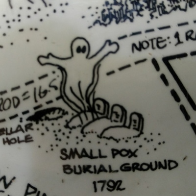
Small Pox Burial Ground E3
Not just an old cemetery but the location of "pest house", a small settlement of infected people from the 18th century. Show Notes: https://lostmassachusetts.com/a-lost-place/f/details-for-episode-3-small-pox-burial-ground
The History of Sudbury
The text image posted here was read during the episode, it is from The History of Sudbury (1889) by Rev. Alfred Sereno Hudson.
Pest House
We visited the location of a long gone Pest House but there is a preserved Pest House in Concord Mass., the The Ephraim Potter House. The Potter house period was concurrent to the Sudbury Pest House and related to the same outbreak.
Maps, etc.
Refer to any one of these articles/descriptions of the Nobscot area: chooseframingham.com, findagrave.com, sudbury.wickedlocal.com, sudburytrails.info, Old Scout Nobscot Map.
Small Pox
Please read this extensive 1932 medical oration on The Story of Smallpox in Massachusetts.
More scout shenanigans, what's a rod? Real pest house, Lost Mass News, how big is a rod? what's up with the postcards? next episode preview. Show Notes: https://lostmassachusetts.com/a-lost-place/f/extra-exploration-small-pox-burial-ground

Dogtown (Part 1): Ghost towns and phantom roads E2
An abandoned settlement in Gloucester and Rockport Mass. A place that has had many lives and changes. Show Notes: https://lostmassachusetts.com/a-lost-place/f/notes-on-episode-2-dogtown---ghost-towns-and-phantom-roads
Route 128 History
bostonroads.com has a comprehensive article on the history of 128.
Credit to Computer History Museum for this cover image of DATAMATION magazine from 1981 showing a cartoon depiction of 128's Tech Boom.
Check out the KIRBY SCUDDER view map of 128
Ghost Towns and ghosttowns.com
We encourage the listeners to visit ghosttowns.com where the details on Hill, New Hampshire, Monson Center/Village, New Hampshire, and Ricker Basin, Vermont. These pages have photos and information supplied to the site by the Lost Massachusetts Podcast Author.
Bellow is the 2008 issue of WOODALL'S containing the Ghost Towns article. There is a more recent issue with the same subject.
Information on Little River State Park in Vermont.
In this bonus episode we provide additional information about Route 128, Ghost Towns, hiking, Lost Mass News, the Paper House and much more!
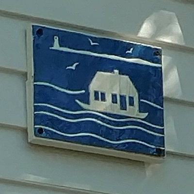
The Floating City- Long Point and Wood End E1
Long Point and Wood End were two salt-producing villages at the tip of Cape Cod that were hit hard economically when mined salt from New York and elsewhere became a less expensive option. The villagers abandoned their towns but took their houses with them by floating them across the bay to Provincetown. The old village houses comprise much of the far West End of Provincetown and have little blue squares on front to of each building to identify them. See: https://lostmassachusetts.com/a-lost-place/f/release-of-the-floating-city-episode-1---long-point-and-wood-end
If you have listened to our first actual podcast episode: The Floating City - Long Point and Wood End, here are additional details and notes to help you on your own hike and historical research.
First, a great overview can be read at CapeCod.com: Hidden Cape Cod: A Village That Used to Exist in Provincetown. Next, the blog Building Provincetown has details about each floating house. The houses are generally on Atwood Avenue, Bradford Street, Commercial Street, Nickerson Street, Pleasant Street, Point Street, Soper Street and Winthrop Street. I would either point you to the specific details in the blog or simply wander the quiet backstreets and look for the blue ceramic tiles with the floating house and the Long Point light in the background. Please note these houses are generally private property. Cape Cod fiction author Barbara Eppich Struna also has a great blog piece about the entire history which includes historic photos and maps. View Mapcarta.com for details on getting to Wood End and Long Point.
In the podcast we give safety advice going to Long Point and accessing the breakwater. To highlight the point, CapeCod.com has a number of articles about emergencies occurring in the area, for example: "Walker suffers possible broken leg at West End Breakwater" and "Woman stranded by by incoming tide near West End". There are many such articles highlighting the actual danger involved in looking for ghost towns and lost places. Other hazards like poison ivy may impact hikers even if they are careful. Listeners can also get the poison ivy treatment Tecnu in our bookstore.
The historical reading authored by Mary Heaton Vorse was from Time and the Town: A Provincetown Chronicle.
Also covering the spelling of Massachusetts, poison ivy, Provincetowns Black Flash phantom, sponsorship of the podcast, skipping rocks, preview and contacting Lost Massachusetts.

Path to Lost Massachusetts: Episode Zero
Drive with us down the dark road to the forgotten forest path that leads to a mysterious place with cracked sidewalks and overgrown cellar holes. We will introduce the show and discuss the original Lost Massachusetts. Show Notes: https://lostmassachusetts.com/a-lost-place/f/path-to-lost-massachusetts-episode-zero